NONAME


Information related to the vessel NONAME (MMSI 799999948, IMO unknown) from with latest positions and portcalls.
| MMSI | 799999948 |
| Name | NONAME |
| Country | |
| MMSI Type | Vessel |
| Type | |
| Id | 608cd6ed1ecbac459b3d8c11 |
| Course | 42.6 |
| Speed (kn) | 7.3 |
| Heading (°) | 44 |
| PAC | |
| ROT | |
| Status |


Leaflet | © OpenStreetMap contributors
| First Seen | 4 years ago |
| Last Update | 4 years ago |
| Positions | 1 |
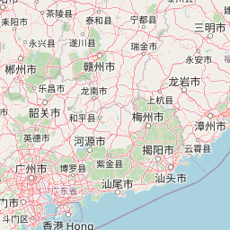
| Latitude | 24.706316666666666 |
| Longitude | 118.791695 |
The vessel NONAME (mmsi 799999948) from country is currently located at 24.706317 N 118.791695 E and the last position is sent 4 years ago. At the moment the vessel is heading 44 degree at speed 7.3 knots, and its current draught is unknown meters. The vessel is long unknown m and large unknown m, and it's estimated to be loaded at 0%.
Timeline
The following timeline will display the list of porcalls and other events regarding the ship including tracks.
- 2021-05-01T04:19:57.911Z
First seen
This vessel has been detected for the first time by Oceanook
