NONAME


Information related to the vessel NONAME (MMSI 789642439, IMO unknown) from with latest positions and portcalls.
| MMSI | 789642439 |
| Name | NONAME |
| Country | |
| MMSI Type | Vessel |
| Type | |
| Id | 679da2671bc4dc56174c0ebb |
| Course | 82.3 |
| Speed (kn) | 66.1 |
| Heading (°) | 265 |
| PAC | |
| ROT | |
| Status |
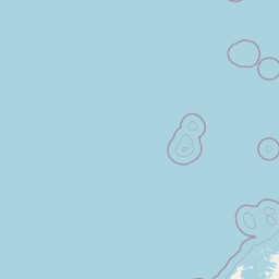


Leaflet | © OpenStreetMap contributors
| First Seen | a month ago |
| Last Update | a month ago |
| Positions | 1 |
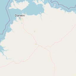
| Latitude | -14.67423 |
| Longitude | 123.282485 |
The vessel NONAME (mmsi 789642439) from country is currently located at -14.674230 S 123.282485 E and the last position is sent a month ago. At the moment the vessel is heading 265 degree at speed 66.1 knots, and its current draught is unknown meters. The vessel is long unknown m and large unknown m, and it's estimated to be loaded at 0%.
Timeline
The following timeline will display the list of porcalls and other events regarding the ship including tracks.
- 2025-02-01T04:26:15.230Z
First seen
This vessel has been detected for the first time by Oceanook
