NONAME


Information related to the vessel NONAME (MMSI 697518987, IMO unknown) from with latest positions and portcalls.
| MMSI | 697518987 |
| Name | NONAME |
| Country | |
| MMSI Type | Vessel |
| Type | |
| Id | 67e74a3b96674d034c4ddf6e |
| Course | 195.9 |
| Speed (kn) | 47.1 |
| Heading (°) | 152 |
| PAC | |
| ROT | |
| Status |


Leaflet | © OpenStreetMap contributors
| First Seen | 2 months ago |
| Last Update | 2 months ago |
| Positions | 1 |
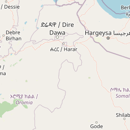
| Latitude | 5.97672 |
| Longitude | 39.489351666666664 |
The vessel NONAME (mmsi 697518987) from country is currently located at 5.976720 N 39.489352 E and the last position is sent 2 months ago. At the moment the vessel is heading 152 degree at speed 47.1 knots, and its current draught is unknown meters. The vessel is long unknown m and large unknown m, and it's estimated to be loaded at 0%.
Timeline
The following timeline will display the list of porcalls and other events regarding the ship including tracks.
