NONAME


Information related to the vessel NONAME (MMSI 667001978, IMO unknown) from Sierra Leone with latest positions and portcalls.
| MMSI | 667001978 |
| Name | NONAME |
| Country | Sierra Leone |
| MMSI Type | Vessel |
| Type | |
| Class | A |
| Id | 60c92eb91bb5222efd88c515 |
| Course | 116.9 |
| Speed (kn) | 9 |
| Heading (°) | 117 |
| PAC | |
| ROT | 0 |
| Status | Under way sailing |


Leaflet | © OpenStreetMap contributors
| First Seen | 4 years ago |
| Last Update | 10 days ago |
| Positions | 798 |
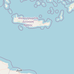
| Latitude | 36.490298333333335 |
| Longitude | 28.288761666666666 |
Distance travelled (nm)
| Since first seen | 65396.39 |
| Since last port call | 1130.66 |
| Since last position | 0 |
Speed (kn) / Draught (m)
The vessel NONAME (mmsi 667001978) from country Sierra Leone is currently located at 36.490298 N 28.288762 E and the last position is sent 10 days ago. At the moment the vessel is Under way sailing heading 117 degree at speed 9 knots, and its current draught is unknown meters. The vessel is long unknown m and large unknown m, and it's estimated to be loaded at 0%.
Timeline
The following timeline will display the list of porcalls and other events regarding the ship including tracks.
