BALLA
Tanker


Information related to the Tanker vessel BALLA (MMSI 636021796, IMO unknown) from Liberia with latest positions and portcalls.
| MMSI | 636021796 |
| Name | BALLA |
| Country | Liberia |
| MMSI Type | Vessel |
| Type | Tanker |
| Call Sign | 5LFS5 |
| Class | A |
| Id | 6329e0cb621e196ac6a18ccc |
| Course | 79.6 |
| Speed (kn) | 0.4 |
| Heading (°) | 307 |
| PAC | |
| ROT | -5.401474888342364 |
| Status | At anchor |


Leaflet | © OpenStreetMap contributors
| First Seen | 3 years ago |
| Last Update | 2 hours ago |
| Positions | 765 |
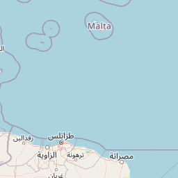
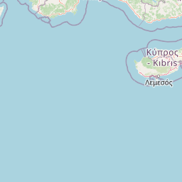
| Latitude | 35.896681666666666 |
| Longitude | 14.85527 |
| Length (m) | 250 |
| Width (m) | 44 |
Distance travelled (nm)
| Since first seen | 150539.82 |
| Since last port call | 752.72 |
| Since last position | 0.04 |
Estimated Load
80%
Speed (kn) / Draught (m)
Draught (m)
| Current | 12 |
| Min | 8 |
| Max | 13 |
| Average | 11.25 |
The Tanker vessel BALLA (mmsi 636021796) from country Liberia is currently located at 35.896682 N 14.855270 E and the last position is sent 2 hours ago. At the moment the vessel is At anchor heading 307 degree at speed 0.4 knots, and its current draught is 12 meters. The vessel is long 250 m and large 44 m, and it's estimated to be loaded at 80%.
Timeline
The following timeline will display the list of porcalls and other events regarding the ship including tracks.
- 2025-04-19T20:45:28.091Z - 2025-04-25T10:30:22.432Z
Navigation (46 positions)
- 2025-04-19T20:45:28.091Z
Departure from Vado Ligure
- 2025-04-19T03:00:04.830Z - 2025-04-19T20:45:28.091Z
Navigation (3 positions)
- 2025-04-19T03:00:04.830Z
Arrival to Vado Ligure
- 2025-04-18T08:57:41.070Z - 2025-04-19T03:00:04.830Z
Navigation (3 positions)
- 2025-04-18T08:57:41.070Z
Departure from Savona
- 2025-04-18T05:48:52.752Z
Arrival to Savona
- 2025-04-15T06:38:47.170Z - 2025-04-18T05:48:52.752Z
Navigation (102 positions)
- 2025-04-15T06:38:47.170Z
Departure from Savona
- 2025-04-15T06:09:28.692Z
Arrival to Savona
- 2025-04-03T08:42:18.709Z - 2025-04-15T06:09:28.692Z
Navigation (115 positions)
- 2025-04-03T08:42:18.709Z
Departure from Savona
- 2025-04-03T04:15:01.356Z
Arrival to Savona
- 2025-02-22T02:07:12.027Z - 2025-04-03T04:15:01.356Z
Navigation (111 positions)
- 2025-02-22T02:07:12.027Z
Departure from Sandvik, Styrsö
- 2025-02-20T19:27:35.215Z
Arrival to Sandvik, Styrsö
- 2023-07-12T08:22:53.478Z
Name changed
This vessel has changed its name to BALLA
- 2022-09-20T15:48:27.225Z
First seen
This vessel has been detected for the first time by Oceanook
