NONAME


Information related to the vessel NONAME (MMSI 636000140, IMO unknown) from Liberia with latest positions and portcalls.
| MMSI | 636000140 |
| Name | NONAME |
| Country | Liberia |
| MMSI Type | Vessel |
| Type | |
| Class | A |
| Id | 679edd071bc4dc561728e0b4 |
| Course | 20.2 |
| Speed (kn) | 14.7 |
| Heading (°) | 21 |
| PAC | |
| ROT | 0 |
| Status | Under way using engine |


Leaflet | © OpenStreetMap contributors
| First Seen | a month ago |
| Last Update | a month ago |
| Positions | 1 |
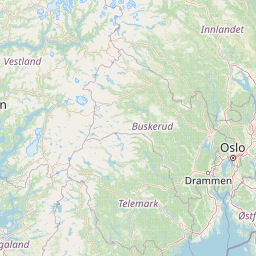
| Latitude | 59.081221666666664 |
| Longitude | 10.60291 |
The vessel NONAME (mmsi 636000140) from country Liberia is currently located at 59.081222 N 10.602910 E and the last position is sent a month ago. At the moment the vessel is Under way using engine heading 21 degree at speed 14.7 knots, and its current draught is unknown meters. The vessel is long unknown m and large unknown m, and it's estimated to be loaded at 0%.
Timeline
The following timeline will display the list of porcalls and other events regarding the ship including tracks.
