NONAME


Information related to the vessel NONAME (MMSI 577592997, IMO unknown) from Vanuatu with latest positions and portcalls.
| MMSI | 577592997 |
| Name | NONAME |
| Country | Vanuatu |
| MMSI Type | Vessel |
| Type | |
| Class | A |
| Id | 679db97d1bc4dc56175bed61 |
| Course | 339.5 |
| Speed (kn) | 51.2 |
| Heading (°) | 36 |
| PAC | |
| ROT | -94.45885011349125 |
| Status | Under way sailing |


Leaflet | © OpenStreetMap contributors
| First Seen | a month ago |
| Last Update | a month ago |
| Positions | 1 |
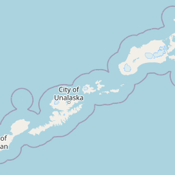
| Latitude | 52.45793333333334 |
| Longitude | -163.19434 |
The vessel NONAME (mmsi 577592997) from country Vanuatu is currently located at 52.457933 N -163.194340 W and the last position is sent a month ago. At the moment the vessel is Under way sailing heading 36 degree at speed 51.2 knots, and its current draught is unknown meters. The vessel is long unknown m and large unknown m, and it's estimated to be loaded at 0%.
Timeline
The following timeline will display the list of porcalls and other events regarding the ship including tracks.
- 2025-02-01T06:04:45.516Z
First seen
This vessel has been detected for the first time by Oceanook
