NONAME


Information related to the vessel NONAME (MMSI 573728797, IMO unknown) from with latest positions and portcalls.
| MMSI | 573728797 |
| Name | NONAME |
| Country | |
| MMSI Type | Vessel |
| Type | |
| Class | A |
| Id | 679efebf1bc4dc56173fd834 |
| Course | 23.9 |
| Speed (kn) | 29.2 |
| Heading (°) | 58 |
| PAC | |
| ROT | 231.41525472038688 |
| Status | Not under command |


Leaflet | © OpenStreetMap contributors
| First Seen | a month ago |
| Last Update | a month ago |
| Positions | 1 |
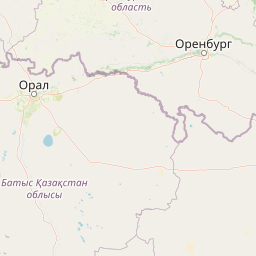
| Latitude | 52.30487333333333 |
| Longitude | 64.97006 |
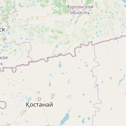
The vessel NONAME (mmsi 573728797) from country is currently located at 52.304873 N 64.970060 E and the last position is sent a month ago. At the moment the vessel is Not under command heading 58 degree at speed 29.2 knots, and its current draught is unknown meters. The vessel is long unknown m and large unknown m, and it's estimated to be loaded at 0%.
Timeline
The following timeline will display the list of porcalls and other events regarding the ship including tracks.
- 2025-02-02T05:12:31.223Z
First seen
This vessel has been detected for the first time by Oceanook
