NONAME


Information related to the vessel NONAME (MMSI 572560220, IMO unknown) from Tuvalu with latest positions and portcalls.
| MMSI | 572560220 |
| Name | NONAME |
| Country | Tuvalu |
| MMSI Type | Vessel |
| Type | |
| Class | A |
| Id | 637d0086eb17d60cbf77ce06 |
| Course | 323 |
| Speed (kn) | 0 |
| Heading (°) | 33 |
| PAC | |
| ROT | 0 |
| Status | Restricted manoeuverability |


Leaflet | © OpenStreetMap contributors
| First Seen | 2 years ago |
| Last Update | 8 months ago |
| Positions | 475 |
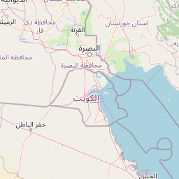
| Latitude | 26.16496 |
| Longitude | 50.67474333333333 |
Distance travelled (nm)
| Since first seen | 13694.84 |
| Since last port call | 4.96 |
| Since last position | 0 |
Speed (kn) / Draught (m)
The vessel NONAME (mmsi 572560220) from country Tuvalu is currently located at 26.164960 N 50.674743 E and the last position is sent 8 months ago. At the moment the vessel is Restricted manoeuverability heading 33 degree at speed 0 knots, and its current draught is unknown meters. The vessel is long unknown m and large unknown m, and it's estimated to be loaded at 0%.
Timeline
The following timeline will display the list of porcalls and other events regarding the ship including tracks.
