NONAME


Information related to the vessel NONAME (MMSI 525001047, IMO unknown) from Indonesia with latest positions and portcalls.
| MMSI | 525001047 |
| Name | NONAME |
| Country | Indonesia |
| MMSI Type | Vessel |
| Type | |
| Class | A |
| Id | 5c4873ce64fa283195d94172 |
| Course | 69.8 |
| Speed (kn) | 0 |
| Heading (°) | 172 |
| PAC | |
| ROT | 0 |
| Status | Restricted manoeuverability |


Leaflet | © OpenStreetMap contributors
| First Seen | 6 years ago |
| Last Update | 7 minutes ago |
| Positions | 563 |
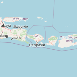
| Latitude | -7.207483333333333 |
| Longitude | 112.72982666666667 |
Distance travelled (nm)
| Since first seen | 24143.18 |
| Since last port call | 36.71 |
| Since last position | 0 |
Speed (kn) / Draught (m)
The vessel NONAME (mmsi 525001047) from country Indonesia is currently located at -7.207483 S 112.729827 E and the last position is sent 7 minutes ago. At the moment the vessel is Restricted manoeuverability heading 172 degree at speed 0 knots, and its current draught is unknown meters. The vessel is long unknown m and large unknown m, and it's estimated to be loaded at 0%.
Timeline
The following timeline will display the list of porcalls and other events regarding the ship including tracks.
