NONAME
Tug


Information related to the Tug vessel NONAME (MMSI 471143000, IMO unknown) from with latest positions and portcalls.
| MMSI | 471143000 |
| Name | NONAME |
| Country | |
| MMSI Type | Vessel |
| Type | Tug |
| Call Sign | A6E2721 |
| Class | A |
| Id | 5e26830148a87370d3b75354 |
| Course | 181.3 |
| Speed (kn) | 0.5 |
| Heading (°) | |
| PAC | |
| ROT | |
| Status | Not defined (default) |


Leaflet | © OpenStreetMap contributors
| First Seen | 5 years ago |
| Last Update | 5 months ago |
| Positions | 454 |
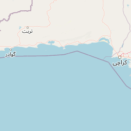
| Latitude | 25.69249 |
| Longitude | 55.77231666666667 |
| Length (m) | 20 |
| Width (m) | 6 |
Distance travelled (nm)
| Since first seen | 4138.55 |
| Since last port call | 0.24 |
| Since last position | 0.12 |
Speed (kn) / Draught (m)
The Tug vessel NONAME (mmsi 471143000) from country is currently located at 25.692490 N 55.772317 E and the last position is sent 5 months ago. At the moment the vessel is Not defined (default) heading degree at speed 0.5 knots, and its current draught is unknown meters. The vessel is long 20 m and large 6 m, and it's estimated to be loaded at 0%.
Timeline
The following timeline will display the list of porcalls and other events regarding the ship including tracks.
