NONAME


Information related to the vessel NONAME (MMSI 419001993, IMO unknown) from Territory with latest positions and portcalls.
| MMSI | 419001993 |
| Name | NONAME |
| Country | Territory |
| MMSI Type | Vessel |
| Type | |
| Class | A |
| Id | 679d31731bc4dc5617fdff94 |
| Course | 238.2 |
| Speed (kn) | 0 |
| Heading (°) | 50 |
| PAC | |
| ROT | 0 |
| Status | Under way using engine |


Leaflet | © OpenStreetMap contributors
| First Seen | a month ago |
| Last Update | 4 days ago |
| Positions | 17 |
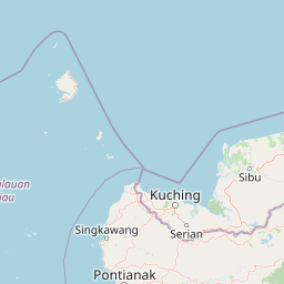
| Latitude | 1.0691333333333333 |
| Longitude | 103.90371833333333 |
Distance travelled (nm)
| Since first seen | 600.22 |
| Since last port call | 3.78 |
| Since last position | 0 |
Speed (kn) / Draught (m)
The vessel NONAME (mmsi 419001993) from country Territory is currently located at 1.069133 N 103.903718 E and the last position is sent 4 days ago. At the moment the vessel is Under way using engine heading 50 degree at speed 0 knots, and its current draught is unknown meters. The vessel is long unknown m and large unknown m, and it's estimated to be loaded at 0%.
Timeline
The following timeline will display the list of porcalls and other events regarding the ship including tracks.
- 2025-02-20T09:16:49.333Z
Arrival to Sekupang
- 2025-02-06T10:03:48.074Z - 2025-02-20T09:16:49.333Z
Navigation (4 positions)
- 2025-02-06T10:03:48.074Z
Departure from Sekupang
- 2025-02-06T05:15:06.752Z
Arrival to Sekupang
- 2025-01-31T20:24:19.450Z
First seen
This vessel has been detected for the first time by Oceanook
