NONAME


Information related to the vessel NONAME (MMSI 407870179, IMO unknown) from with latest positions and portcalls.
| MMSI | 407870179 |
| Name | NONAME |
| Country | |
| MMSI Type | Vessel |
| Type | |
| Id | 679d95d91bc4dc5617436ad4 |
| Course | 124.2 |
| Speed (kn) | 15.1 |
| Heading (°) | 383 |
| PAC | |
| ROT | |
| Status |

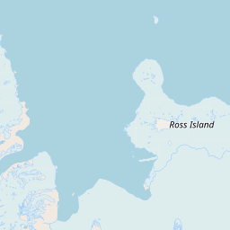


Leaflet | © OpenStreetMap contributors
| First Seen | a month ago |
| Last Update | a month ago |
| Positions | 1 |
| Latitude | -76.46100166666666 |
| Longitude | 163.98695666666666 |
The vessel NONAME (mmsi 407870179) from country is currently located at -76.461002 S 163.986957 E and the last position is sent a month ago. At the moment the vessel is heading 383 degree at speed 15.1 knots, and its current draught is unknown meters. The vessel is long unknown m and large unknown m, and it's estimated to be loaded at 0%.
Timeline
The following timeline will display the list of porcalls and other events regarding the ship including tracks.
- 2025-02-01T03:32:41.574Z
First seen
This vessel has been detected for the first time by Oceanook
