NONAME


Information related to the vessel NONAME (MMSI 368404260, IMO unknown) from United States of America with latest positions and portcalls.
| MMSI | 368404260 |
| Name | NONAME |
| Country | United States of America |
| MMSI Type | Vessel |
| Type | |
| Class | A |
| Id | 67e30e5696674d034c1aef23 |
| Course | 266.3 |
| Speed (kn) | 0 |
| Heading (°) | 232 |
| PAC | |
| ROT | 0.7142446133345274 |
| Status | Moored |


Leaflet | © OpenStreetMap contributors
| First Seen | 3 days ago |
| Last Update | 2 days ago |
| Positions | 1 |
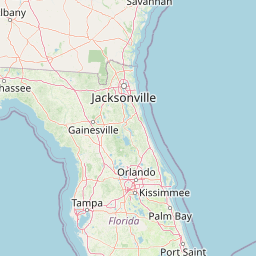
| Latitude | 30.40017 |
| Longitude | -81.432335 |
Distance travelled (nm)
| Since first seen | 0 |
| Since last port call | 0 |
| Since last position | 0 |
The vessel NONAME (mmsi 368404260) from country United States of America is currently located at 30.400170 N -81.432335 W and the last position is sent 2 days ago. At the moment the vessel is Moored heading 232 degree at speed 0 knots, and its current draught is unknown meters. The vessel is long unknown m and large unknown m, and it's estimated to be loaded at 0%.
Timeline
The following timeline will display the list of porcalls and other events regarding the ship including tracks.
- 2025-03-25T20:13:10.193Z
First seen
This vessel has been detected for the first time by Oceanook
