NONAME


Information related to the vessel NONAME (MMSI 368400060, IMO unknown) from United States of America with latest positions and portcalls.
| MMSI | 368400060 |
| Name | NONAME |
| Country | United States of America |
| MMSI Type | Vessel |
| Type | |
| Class | A |
| Id | 6799c1b91bc4dc56178d8493 |
| Course | 347.7 |
| Speed (kn) | 0 |
| Heading (°) | 292 |
| PAC | |
| ROT | 0 |
| Status | Not defined (default) |

Leaflet | © OpenStreetMap contributors
| First Seen | 17 days ago |
| Last Update | 2 days ago |
| Positions | 1 |
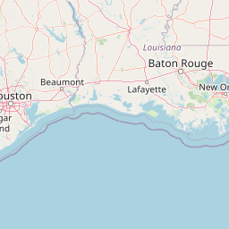
| Latitude | 29.572345 |
| Longitude | -90.59385 |
Distance travelled (nm)
| Since first seen | 0.06 |
| Since last port call | 0.06 |
| Since last position | 0 |
The vessel NONAME (mmsi 368400060) from country United States of America is currently located at 29.572345 N -90.593850 W and the last position is sent 2 days ago. At the moment the vessel is Not defined (default) heading 292 degree at speed 0 knots, and its current draught is unknown meters. The vessel is long unknown m and large unknown m, and it's estimated to be loaded at 0%.
Timeline
The following timeline will display the list of porcalls and other events regarding the ship including tracks.
