NONAME
Tug


Information related to the Tug vessel NONAME (MMSI 368330610, IMO unknown) from United States of America with latest positions and portcalls.
| MMSI | 368330610 |
| Name | NONAME |
| Country | United States of America |
| MMSI Type | Vessel |
| Type | Tug |
| Call Sign | WDN9826 |
| Class | A |
| Id | 679cff051bc4dc5617d915c8 |
| Course | 143.3 |
| Speed (kn) | 0.7 |
| Heading (°) | |
| PAC | |
| ROT | |
| Status | Under way using engine |


Leaflet | © OpenStreetMap contributors
| First Seen | a month ago |
| Last Update | 2 days ago |
| Positions | 2 |
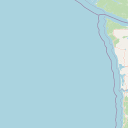
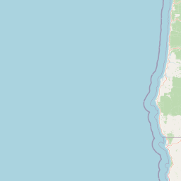
| Latitude | 46.281535 |
| Longitude | -124.04608166666667 |
| Length (m) | 8 |
| Width (m) | 4 |
Distance travelled (nm)
| Since first seen | 2.14 |
| Since last port call | 2.14 |
| Since last position | 0.3 |
The Tug vessel NONAME (mmsi 368330610) from country United States of America is currently located at 46.281535 N -124.046082 W and the last position is sent 2 days ago. At the moment the vessel is Under way using engine heading degree at speed 0.7 knots, and its current draught is unknown meters. The vessel is long 8 m and large 4 m, and it's estimated to be loaded at 0%.
Timeline
The following timeline will display the list of porcalls and other events regarding the ship including tracks.
- 2025-02-27T18:46:43.745Z
Arrival to Chinook
- 2025-01-31T16:49:09.461Z
First seen
This vessel has been detected for the first time by Oceanook
