NONAME


Information related to the vessel NONAME (MMSI 368148737, IMO unknown) from United States of America with latest positions and portcalls.
| MMSI | 368148737 |
| Name | NONAME |
| Country | United States of America |
| MMSI Type | Vessel |
| Type | |
| Id | 679f5c8c1bc4dc5617803db6 |
| Course | |
| Speed (kn) | 0 |
| Heading (°) | |
| PAC | |
| ROT | |
| Status |


Leaflet | © OpenStreetMap contributors
| First Seen | a month ago |
| Last Update | a month ago |
| Positions | 1 |
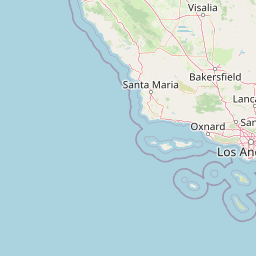
| Latitude | 33.98343166666667 |
| Longitude | -118.45012 |
The vessel NONAME (mmsi 368148737) from country United States of America is currently located at 33.983432 N -118.450120 W and the last position is sent a month ago. At the moment the vessel is heading degree at speed 0 knots, and its current draught is unknown meters. The vessel is long unknown m and large unknown m, and it's estimated to be loaded at 0%.
Timeline
The following timeline will display the list of porcalls and other events regarding the ship including tracks.
- 2025-02-02T11:52:44.670Z
First seen
This vessel has been detected for the first time by Oceanook
