NONAME


Information related to the vessel NONAME (MMSI 345123451, IMO unknown) from Mexico with latest positions and portcalls.
| MMSI | 345123451 |
| Name | NONAME |
| Country | Mexico |
| MMSI Type | Vessel |
| Type | |
| Class | A |
| Id | 65f3618c95262e10b50a4f5c |
| Course | 359.9 |
| Speed (kn) | 0.1 |
| Heading (°) | |
| PAC | |
| ROT | 1.6070503800026865 |
| Status | Under way using engine |


Leaflet | © OpenStreetMap contributors
| First Seen | a year ago |
| Last Update | a year ago |
| Positions | 10 |
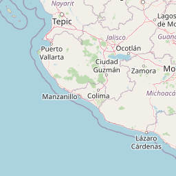
| Latitude | 16.848401666666668 |
| Longitude | -99.903315 |
Distance travelled (nm)
| Since first seen | 44.15 |
| Since last port call | 0.07 |
| Since last position | 0 |
Speed (kn) / Draught (m)
The vessel NONAME (mmsi 345123451) from country Mexico is currently located at 16.848402 N -99.903315 W and the last position is sent a year ago. At the moment the vessel is Under way using engine heading degree at speed 0.1 knots, and its current draught is unknown meters. The vessel is long unknown m and large unknown m, and it's estimated to be loaded at 0%.
Timeline
The following timeline will display the list of porcalls and other events regarding the ship including tracks.
