NONAME


Information related to the vessel NONAME (MMSI 341950000, IMO unknown) from Saint Kitts and Nevis with latest positions and portcalls.
| MMSI | 341950000 |
| Name | NONAME |
| Country | Saint Kitts and Nevis |
| MMSI Type | Vessel |
| Type | |
| Class | A |
| Id | 66cc6a1c71e768ee10df77b4 |
| Course | 195.1 |
| Speed (kn) | 3.9 |
| Heading (°) | 263 |
| PAC | |
| ROT | -2.8569784533381095 |
| Status | Moored |


Leaflet | © OpenStreetMap contributors
| First Seen | 6 months ago |
| Last Update | a month ago |
| Positions | 19 |
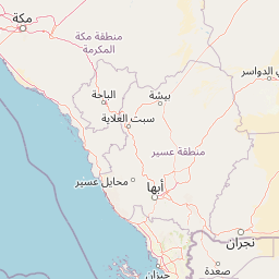
| Latitude | 21.437018333333334 |
| Longitude | 39.14020333333333 |
Distance travelled (nm)
| Since first seen | 344.08 |
| Since last port call | 1.47 |
| Since last position | 0 |
Speed (kn) / Draught (m)
The vessel NONAME (mmsi 341950000) from country Saint Kitts and Nevis is currently located at 21.437018 N 39.140203 E and the last position is sent a month ago. At the moment the vessel is Moored heading 263 degree at speed 3.9 knots, and its current draught is unknown meters. The vessel is long unknown m and large unknown m, and it's estimated to be loaded at 0%.
Timeline
The following timeline will display the list of porcalls and other events regarding the ship including tracks.
