NONAME


Information related to the vessel NONAME (MMSI 338158711, IMO unknown) from United States of America with latest positions and portcalls.
| MMSI | 338158711 |
| Name | NONAME |
| Country | United States of America |
| MMSI Type | Vessel |
| Type | |
| Class | A |
| Id | 67994e3e1bc4dc56173e6810 |
| Course | 82.7 |
| Speed (kn) | 0 |
| Heading (°) | |
| PAC | |
| ROT | |
| Status | Reserved for future use |


Leaflet | © OpenStreetMap contributors
| First Seen | 4 days ago |
| Last Update | 3 minutes ago |
| Positions | 20 |
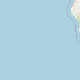
| Latitude | 37.66303666666666 |
| Longitude | -122.37658666666667 |
Distance travelled (nm)
| Since first seen | 92.42 |
| Since last port call | 47.4 |
| Since last position | 0 |
Speed (kn) / Draught (m)
The vessel NONAME (mmsi 338158711) from country United States of America is currently located at 37.663037 N -122.376587 W and the last position is sent 3 minutes ago. At the moment the vessel is Reserved for future use heading degree at speed 0 knots, and its current draught is unknown meters. The vessel is long unknown m and large unknown m, and it's estimated to be loaded at 0%.
Timeline
The following timeline will display the list of porcalls and other events regarding the ship including tracks.