NONAME


Information related to the vessel NONAME (MMSI 263401328, IMO unknown) from Portugal with latest positions and portcalls.
| MMSI | 263401328 |
| Name | NONAME |
| Country | Portugal |
| MMSI Type | Vessel |
| Type | |
| Class | A |
| Id | 679d09151bc4dc5617e08dd6 |
| Course | 78.7 |
| Speed (kn) | 3.5 |
| Heading (°) | 426 |
| PAC | |
| ROT | -285.69784533381096 |
| Status | Not defined (default) |


Leaflet | © OpenStreetMap contributors
| First Seen | a month ago |
| Last Update | a month ago |
| Positions | 1 |
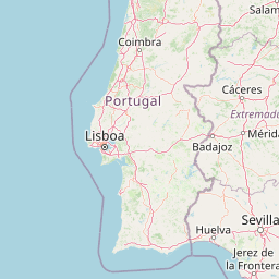
| Latitude | 40.24889 |
| Longitude | -9.008293333333333 |
The vessel NONAME (mmsi 263401328) from country Portugal is currently located at 40.248890 N -9.008293 W and the last position is sent a month ago. At the moment the vessel is Not defined (default) heading 426 degree at speed 3.5 knots, and its current draught is unknown meters. The vessel is long unknown m and large unknown m, and it's estimated to be loaded at 0%.
Timeline
The following timeline will display the list of porcalls and other events regarding the ship including tracks.
