NONAME


Information related to the vessel NONAME (MMSI 256722039, IMO unknown) from Malta with latest positions and portcalls.
| MMSI | 256722039 |
| Name | NONAME |
| Country | Malta |
| MMSI Type | Vessel |
| Type | |
| Class | A |
| Id | 679d213f1bc4dc5617f2439e |
| Course | 39.6 |
| Speed (kn) | 0 |
| Heading (°) | 300 |
| PAC | |
| ROT | 0 |
| Status | At anchor |


Leaflet | © OpenStreetMap contributors
| First Seen | a month ago |
| Last Update | a month ago |
| Positions | 1 |
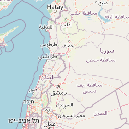
| Latitude | 37.85314 |
| Longitude | 23.535735 |
The vessel NONAME (mmsi 256722039) from country Malta is currently located at 37.853140 N 23.535735 E and the last position is sent a month ago. At the moment the vessel is At anchor heading 300 degree at speed 0 knots, and its current draught is unknown meters. The vessel is long unknown m and large unknown m, and it's estimated to be loaded at 0%.
Timeline
The following timeline will display the list of porcalls and other events regarding the ship including tracks.
- 2025-01-31T19:15:11.347Z
First seen
This vessel has been detected for the first time by Oceanook
