NONAME


Information related to the vessel NONAME (MMSI 235088696, IMO unknown) from United Kingdom with latest positions and portcalls.
| MMSI | 235088696 |
| Name | NONAME |
| Country | United Kingdom |
| MMSI Type | Vessel |
| Type | |
| Class | A |
| Id | 6799bc531bc4dc561789cef7 |
| Course | |
| Speed (kn) | 0 |
| Heading (°) | |
| PAC | |
| ROT | |
| Status | Under way using engine |


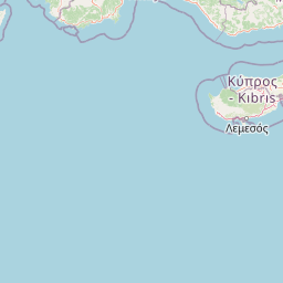

Leaflet | © OpenStreetMap contributors
| First Seen | 17 days ago |
| Last Update | 17 days ago |
| Positions | 1 |
| Latitude | 37.95665833333333 |
| Longitude | 23.605285 |
The vessel NONAME (mmsi 235088696) from country United Kingdom is currently located at 37.956658 N 23.605285 E and the last position is sent 17 days ago. At the moment the vessel is Under way using engine heading degree at speed 0 knots, and its current draught is unknown meters. The vessel is long unknown m and large unknown m, and it's estimated to be loaded at 0%.
Timeline
The following timeline will display the list of porcalls and other events regarding the ship including tracks.
- 2025-01-29T05:27:47.457Z
First seen
This vessel has been detected for the first time by Oceanook
