NONAME


Information related to the vessel NONAME (MMSI 229395001, IMO unknown) from Malta with latest positions and portcalls.
| MMSI | 229395001 |
| Name | NONAME |
| Country | Malta |
| MMSI Type | Vessel |
| Type | |
| Class | A |
| Id | 679f3a6d1bc4dc561768a105 |
| Course | 163 |
| Speed (kn) | 5.1 |
| Heading (°) | 176 |
| PAC | |
| ROT | -160.70503800026864 |
| Status | Not defined (default) |


Leaflet | © OpenStreetMap contributors
| First Seen | a month ago |
| Last Update | a month ago |
| Positions | 1 |
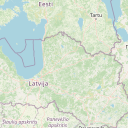
| Latitude | 55.91115 |
| Longitude | 12.7362 |
The vessel NONAME (mmsi 229395001) from country Malta is currently located at 55.911150 N 12.736200 E and the last position is sent a month ago. At the moment the vessel is Not defined (default) heading 176 degree at speed 5.1 knots, and its current draught is unknown meters. The vessel is long unknown m and large unknown m, and it's estimated to be loaded at 0%.
Timeline
The following timeline will display the list of porcalls and other events regarding the ship including tracks.
- 2025-02-02T09:27:09.250Z
First seen
This vessel has been detected for the first time by Oceanook
