NONAME


Information related to the vessel NONAME (MMSI 227118380, IMO unknown) from France with latest positions and portcalls.
| MMSI | 227118380 |
| Name | NONAME |
| Country | France |
| MMSI Type | Vessel |
| Type | |
| Class | A |
| Id | 6536a7fa91531a98dc3969c4 |
| Course | 62.3 |
| Speed (kn) | 4.5 |
| Heading (°) | 355 |
| PAC | |
| ROT | |
| Status | Under way sailing |


Leaflet | © OpenStreetMap contributors
| First Seen | 2 years ago |
| Last Update | 9 days ago |
| Positions | 39 |
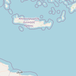
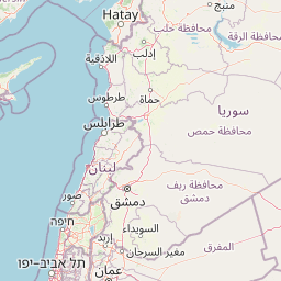
| Latitude | 37.343145 |
| Longitude | 26.697495 |
Distance travelled (nm)
| Since first seen | 401.66 |
| Since last port call | 192.75 |
| Since last position | 0 |
Speed (kn) / Draught (m)
The vessel NONAME (mmsi 227118380) from country France is currently located at 37.343145 N 26.697495 E and the last position is sent 9 days ago. At the moment the vessel is Under way sailing heading 355 degree at speed 4.5 knots, and its current draught is unknown meters. The vessel is long unknown m and large unknown m, and it's estimated to be loaded at 0%.
Timeline
The following timeline will display the list of porcalls and other events regarding the ship including tracks.
- 2025-04-01T11:55:17.169Z - 2025-05-11T04:16:04.804Z
Navigation (18 positions)
- 2025-04-01T11:55:17.169Z
Departure from Agia Marina Aiginas
- 2025-03-28T15:37:41.447Z - 2025-04-01T11:55:17.169Z
Navigation (6 positions)
- 2025-03-28T15:37:41.447Z
Arrival to Agia Marina Aiginas
- 2023-10-23T17:06:02.060Z
First seen
This vessel has been detected for the first time by Oceanook
