NONAME


Information related to the vessel NONAME (MMSI 222368968, IMO unknown) from with latest positions and portcalls.
| MMSI | 222368968 |
| Name | NONAME |
| Country | |
| MMSI Type | Vessel |
| Type | |
| Class | A |
| Id | 679d95131bc4dc561742e0c5 |
| Course | 343.7 |
| Speed (kn) | 2.6 |
| Heading (°) | 295 |
| PAC | |
| ROT | 0 |
| Status | Not under command |


Leaflet | © OpenStreetMap contributors
| First Seen | a month ago |
| Last Update | a month ago |
| Positions | 1 |
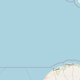
| Latitude | 37.939096666666664 |
| Longitude | 23.671508333333332 |
The vessel NONAME (mmsi 222368968) from country is currently located at 37.939097 N 23.671508 E and the last position is sent a month ago. At the moment the vessel is Not under command heading 295 degree at speed 2.6 knots, and its current draught is unknown meters. The vessel is long unknown m and large unknown m, and it's estimated to be loaded at 0%.
Timeline
The following timeline will display the list of porcalls and other events regarding the ship including tracks.
- 2025-02-01T03:29:23.937Z
First seen
This vessel has been detected for the first time by Oceanook
