NONAME


Information related to the vessel NONAME (MMSI 215643193, IMO unknown) from Malta with latest positions and portcalls.
| MMSI | 215643193 |
| Name | NONAME |
| Country | Malta |
| MMSI Type | Vessel |
| Type | |
| Class | A |
| Id | 679cd0eb1bc4dc5617b76e8a |
| Course | 344 |
| Speed (kn) | 0.1 |
| Heading (°) | |
| PAC | |
| ROT | -708.7092175811848 |
| Status | Under way using engine |


Leaflet | © OpenStreetMap contributors
| First Seen | a month ago |
| Last Update | a month ago |
| Positions | 1 |
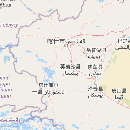
| Latitude | 36.182383333333334 |
| Longitude | 78.94980666666666 |
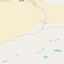
The vessel NONAME (mmsi 215643193) from country Malta is currently located at 36.182383 N 78.949807 E and the last position is sent a month ago. At the moment the vessel is Under way using engine heading degree at speed 0.1 knots, and its current draught is unknown meters. The vessel is long unknown m and large unknown m, and it's estimated to be loaded at 0%.
Timeline
The following timeline will display the list of porcalls and other events regarding the ship including tracks.
