NONAME


Information related to the vessel NONAME (MMSI 210697000, IMO unknown) from Cyprus with latest positions and portcalls.
| MMSI | 210697000 |
| Name | NONAME |
| Country | Cyprus |
| MMSI Type | Vessel |
| Type | |
| Class | A |
| Id | 66cc5c3a71e768ee10d8f415 |
| Course | 1 |
| Speed (kn) | 0 |
| Heading (°) | 261 |
| PAC | |
| ROT | 0 |
| Status | Under way sailing |


Leaflet | © OpenStreetMap contributors
| First Seen | 6 months ago |
| Last Update | a month ago |
| Positions | 66 |
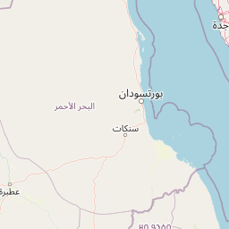
| Latitude | 21.469665 |
| Longitude | 39.15056666666667 |
Distance travelled (nm)
| Since first seen | 67.45 |
| Since last port call | 6.08 |
| Since last position | 0 |
Speed (kn) / Draught (m)
The vessel NONAME (mmsi 210697000) from country Cyprus is currently located at 21.469665 N 39.150567 E and the last position is sent a month ago. At the moment the vessel is Under way sailing heading 261 degree at speed 0 knots, and its current draught is unknown meters. The vessel is long unknown m and large unknown m, and it's estimated to be loaded at 0%.
Timeline
The following timeline will display the list of porcalls and other events regarding the ship including tracks.
