NONAME


Information related to the vessel NONAME (MMSI 574015097, IMO unknown) from Viet Nam with latest positions and portcalls.
| MMSI | 574015097 |
| Name | NONAME |
| Country | Viet Nam |
| MMSI Type | Vessel |
| Type | |
| Class | A |
| Id | 67e30b0696674d034c186946 |
| Course | 343.7 |
| Speed (kn) | 7.6 |
| Heading (°) | |
| PAC | |
| ROT | |
| Status | Not defined (default) |


Leaflet | © OpenStreetMap contributors
| First Seen | 6 days ago |
| Last Update | 6 days ago |
| Positions | 2 |
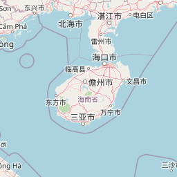
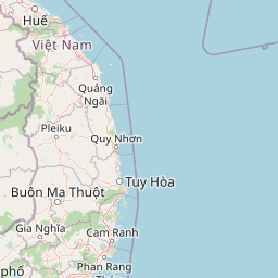
| Latitude | 14.6107 |
| Longitude | 109.18903333333333 |
Distance travelled (nm)
| Since first seen | 4.09 |
| Since last port call | 4.09 |
| Since last position | 0.84 |
The vessel NONAME (mmsi 574015097) from country Viet Nam is currently located at 14.610700 N 109.189033 E and the last position is sent 6 days ago. At the moment the vessel is Not defined (default) heading degree at speed 7.6 knots, and its current draught is unknown meters. The vessel is long unknown m and large unknown m, and it's estimated to be loaded at 0%.
Timeline
The following timeline will display the list of porcalls and other events regarding the ship including tracks.
- 2025-03-25T19:59:02.238Z
First seen
This vessel has been detected for the first time by Oceanook
