NONAME

Tanker

FacebookLinkedInTwitterRedditVKPrint

Information related to the Tanker vessel NONAME (MMSI 538006249, IMO 9710323) from Marshall Islands with latest positions and portcalls.

MMSI538006249
IMO9710323
NameNONAME
Country Marshall Islands
MMSI TypeVessel
TypeTanker
Call SignV7LA9
ClassA
Id5c8da031df27e971157251fb
Course179.6
Speed (kn)7.8
Heading (°)179
PAC
ROT-7.544208728345946
StatusUnder way using engine
Leaflet | © OpenStreetMap contributors

First Seen6 years ago
Last Update5 days ago
Positions1377
Latitude38.930836666666664
Longitude-10.204588333333334
Length (m)95
Width (m)16
ETAMay 28, 2023 12:00 AM

Distance travelled (nm)

Since first seen267481.59
Since last port call1255.61
Since last position0

Speed (kn) / Draught (m)

Wed 16Thu 17Fri 18Sat 19Sun 20Mon 21Tue 22Wed 23April 2025

Draught (m)

Current4
Min4
Max5.7
Average5.06

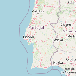
The Tanker vessel NONAME (mmsi 538006249) from country Marshall Islands is currently located at 38.930837 N -10.204588 W and the last position is sent 5 days ago. At the moment the vessel is Under way using engine heading 179 degree at speed 7.8 knots, and its current draught is 4 meters. The vessel is long 95 m and large 16 m, and it's estimated to be loaded at 0%.

Timeline

The following timeline will display the list of porcalls and other events regarding the ship including tracks.