NONAME
钓鱼


与来自 中国 的 钓鱼 船 NONAME(mmsi 412341245,imo 未知)相关的信息以及最新位置和港口停靠。
| MMSI | 412341245 |
| 姓名 | NONAME |
| 国家 | 中国 |
| MMSI 类型 | 血管 |
| 类型 | 钓鱼 |
| 班级 | B |
| Id | 5c48e6a3ee377e385b314d3f |
| 课程 | 228.7 |
| 速度 (kn) | 4.1 |
| 标题 (°) | |
| PAC | |
| ROT | |
| 地位 |


Leaflet | © OpenStreetMap contributors
| 第一次见到 | 6 years ago |
| 最后更新 | 2 years ago |
| 职位 | 421 |
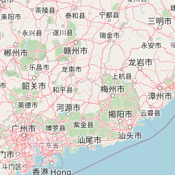
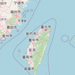
| Latitude | 24.227708333333332 |
| Longitude | 118.21139333333333 |
| 长度 (m) | 20 |
| 宽度 (m) | 5 |
行驶距离 (nm)
| 自从第一次见到 | 1521.98 |
| 自上次靠港以来 | 48.58 |
| 自上次位置以来 | 0 |
速度 (kn) / 吃水 (m)
来自国家 中国 的 钓鱼 船只 NONAME (mmsi 412341245) 当前位于 24.227708 N 118.211393 E,最后位置发送 。 目前该船以 4.1 节的速度 航向 度,其当前吃水为 未知 米。 该船长20 m,大5 m,估计装载量为%。
时间线
以下时间线将显示有关船舶的 porcalls 和其他事件的列表,包括轨道。
- 2021-11-02T15:29:58.996Z - 2025-03-18T10:09:21.286Z
导航 (7 职位)
- 2022-11-09T08:14:21.635Z
名称已更改
这艘船已更名为 NONAME
- 2021-11-02T15:29:58.996Z
出发地 Xiamen Pt
- 2021-11-02T04:02:31.588Z - 2021-11-02T15:29:58.996Z
导航 (2 职位)
- 2021-11-02T04:02:31.588Z
到达 Xiamen Pt
- 2021-10-27T18:29:58.135Z - 2021-11-02T04:02:31.588Z
导航 (5 职位)
- 2021-10-27T18:29:58.135Z
出发地 Xiamen Pt
- 2021-10-27T09:49:37.659Z
到达 Xiamen Pt
- 2021-09-22T06:44:28.197Z - 2021-10-27T09:49:37.659Z
导航 (15 职位)
- 2021-09-22T06:44:28.197Z
出发地 Shenhu
- 2021-09-22T06:14:30.306Z - 2021-09-22T06:44:28.197Z
导航 (2 职位)
- 2021-09-22T06:14:30.306Z
到达 Shenhu
- 2021-08-19T03:11:11.561Z - 2021-09-22T06:14:30.306Z
导航 (2 职位)
- 2021-08-19T03:11:11.561Z
出发地 Xiamen Pt
- 2021-08-18T21:12:23.893Z
到达 Xiamen Pt
- 2021-08-16T03:22:16.588Z - 2021-08-18T21:12:23.893Z
导航 (11 职位)
- 2021-08-16T03:22:16.588Z
出发地 Xiamen
- 2021-08-16T02:50:45.310Z
到达 Xiamen
- 2021-04-08T01:10:33.115Z
名称已更改
这艘船已更名为 60827
- 2019-05-08T08:06:52.655Z
名称已更改
这艘船已更名为
- 2019-01-23T22:11:47.107Z
名称已更改
这艘船已更名为 63103
- 2019-01-23T22:11:47.107Z
第一次见到
该船首次被oceanook检测到
