NONAME


Information related to the vessel NONAME (MMSI 224364880, IMO unknown) from Spain with latest positions and portcalls.
| MMSI | 224364880 |
| Name | NONAME |
| Country | Spain |
| MMSI Type | Vessel |
| Type | |
| Class | A |
| Id | 5d383f3d78e71d709b999cc7 |
| Course | 77 |
| Speed (kn) | 1.9 |
| Heading (°) | |
| PAC | |
| ROT | 125.39456992854296 |
| Status | Not defined (default) |


Leaflet | © OpenStreetMap contributors
| First Seen | 6 years ago |
| Last Update | 10 days ago |
| Positions | 498 |
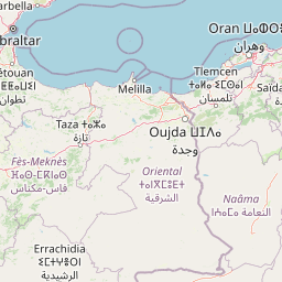
| Latitude | 36.63773166666667 |
| Longitude | -2.569425 |
Distance travelled (nm)
| Since first seen | 18399.86 |
| Since last port call | 636.69 |
| Since last position | 0 |
Speed (kn) / Draught (m)
The vessel NONAME (mmsi 224364880) from country Spain is currently located at 36.637732 N -2.569425 W and the last position is sent 10 days ago. At the moment the vessel is Not defined (default) heading degree at speed 1.9 knots, and its current draught is unknown meters. The vessel is long unknown m and large unknown m, and it's estimated to be loaded at 0%.
Timeline
The following timeline will display the list of porcalls and other events regarding the ship including tracks.
