NUEVO OLIMAR
Fishing


Information related to the Fishing vessel NUEVO OLIMAR (MMSI 224181470, IMO unknown) from Spain with latest positions and portcalls.
| MMSI | 224181470 |
| Name | NUEVO OLIMAR |
| Country | Spain |
| MMSI Type | Vessel |
| Type | Fishing |
| Call Sign | DATAHUB |
| Class | A |
| Id | 5ca4263aed09d014505f541e |
| Course | 48.4 |
| Speed (kn) | 7.3 |
| Heading (°) | 117 |
| PAC | |
| ROT | 125.39456992854296 |
| Status | Under way using engine |


Leaflet | © OpenStreetMap contributors
| First Seen | 6 years ago |
| Last Update | 2 days ago |
| Positions | 489 |
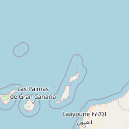
| Latitude | 27.93215 |
| Longitude | -15.216095 |
Distance travelled (nm)
| Since first seen | 23077.88 |
| Since last port call | 831.55 |
| Since last position | 0 |
Speed (kn) / Draught (m)
Draught (m)
| Current | 1 |
| Min | 1 |
| Max | 1.3 |
| Average | 1 |
The Fishing vessel NUEVO OLIMAR (mmsi 224181470) from country Spain is currently located at 27.932150 N -15.216095 W and the last position is sent 2 days ago. At the moment the vessel is Under way using engine heading 117 degree at speed 7.3 knots, and its current draught is 1 meters. The vessel is long unknown m and large unknown m, and it's estimated to be loaded at 0%.
Timeline
The following timeline will display the list of porcalls and other events regarding the ship including tracks.
