CEMISLE

Cargo

FacebookLinkedInTwitterRedditVKPrint

Information related to the Cargo vessel CEMISLE (MMSI 305399000, IMO 9213911) from Antigua and Barbuda with latest positions and portcalls.

MMSI305399000
IMO9213911
NameCEMISLE
Country Antigua and Barbuda
MMSI TypeVessel
TypeCargo
Call SignV2EE4
ClassA
Id5c4c7dfde8f73a40a1e0ec32
Course109.9
Speed (kn)7.9
Heading (°)110
PAC
ROT0
StatusUnder way using engine
Leaflet | © OpenStreetMap contributors

First Seen6 years ago
Last Update2 days ago
Positions1726
Latitude38.353833333333334
Longitude-9.2415
Length (m)120
Width (m)17
ETANov 26, 2024 12:00 AM

Distance travelled (nm)

Since first seen473735.98
Since last port call1674.6
Since last position0.72

Estimated Load

17%

Speed (kn) / Draught (m)

Wed 2Thu 3Fri 4Sat 5Sun 6Mon 7April 2025

Draught (m)

Current4.5
Min2.3
Max14.6
Average5.64

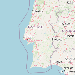
The Cargo vessel CEMISLE (mmsi 305399000) from country Antigua and Barbuda is currently located at 38.353833 N -9.241500 W and the last position is sent 2 days ago. At the moment the vessel is Under way using engine heading 110 degree at speed 7.9 knots, and its current draught is 4.5 meters. The vessel is long 120 m and large 17 m, and it's estimated to be loaded at 17%.

Timeline

The following timeline will display the list of porcalls and other events regarding the ship including tracks.