BARUNGA

Tug

FacebookLinkedInTwitterRedditVKPrint

Information related to the Tug vessel BARUNGA (MMSI 503090600, IMO 9277606) from Australia with latest positions and portcalls.

MMSI503090600
IMO9277606
NameBARUNGA
Country Australia
MMSI TypeVessel
TypeTug
Call SignVNFS
ClassA
Id5c6a366c6401fa61eacc5847
Course342
Speed (kn)0
Heading (°)297
PAC
ROT0
StatusMoored
Leaflet | © OpenStreetMap contributors

First Seen6 years ago
Last Update19 minutes ago
Positions592
Latitude-34.836983333333336
Longitude138.51115
Length (m)24
Width (m)11
ETAMay 19, 2025 12:00 AM

Distance travelled (nm)

Since first seen46288.67
Since last port call0.79
Since last position0

Speed (kn) / Draught (m)

Mon 21Tue 22Wed 23Thu 24Fri 25Sat 26Sun 27Mon 28Tue 29Wed 30Thu 1Fri 2April 2025

Draught (m)

Current5.2
Min5
Max5.2
Average5.2

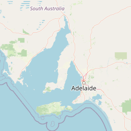
The Tug vessel BARUNGA (mmsi 503090600) from country Australia is currently located at -34.836983 S 138.511150 E and the last position is sent 19 minutes ago. At the moment the vessel is Moored heading 297 degree at speed 0 knots, and its current draught is 5.2 meters. The vessel is long 24 m and large 11 m, and it's estimated to be loaded at 0%.

Timeline

The following timeline will display the list of porcalls and other events regarding the ship including tracks.