NONAME
Fishing


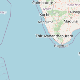
Information related to the Fishing vessel NONAME (MMSI 417051734, IMO unknown) from Sri Lanka with latest positions and portcalls.
| MMSI | 417051734 |
| Name | NONAME |
| Country | Sri Lanka |
| MMSI Type | Vessel |
| Type | Fishing |
| Call Sign | 4SF4029 |
| Id | 6799475e1bc4dc5617399caf |
| Course | 90.8 |
| Speed (kn) | 4 |
| Heading (°) | 90 |
| PAC | |
| ROT | |
| Status |


Leaflet | © OpenStreetMap contributors
| First Seen | a month ago |
| Last Update | 19 days ago |
| Positions | 5 |
| Latitude | 5.920193333333334 |
| Longitude | 80.26067833333333 |
| Length (m) | 12 |
| Width (m) | 4 |
Distance travelled (nm)
| Since first seen | 20.99 |
| Since last port call | 20.99 |
| Since last position | 0 |
The Fishing vessel NONAME (mmsi 417051734) from country Sri Lanka is currently located at 5.920193 N 80.260678 E and the last position is sent 19 days ago. At the moment the vessel is heading 90 degree at speed 4 knots, and its current draught is unknown meters. The vessel is long 12 m and large 4 m, and it's estimated to be loaded at 0%.
Timeline
The following timeline will display the list of porcalls and other events regarding the ship including tracks.
- 2025-01-28T21:08:46.055Z
First seen
This vessel has been detected for the first time by Oceanook
