NONAME


Information related to the vessel NONAME (MMSI 380001734, IMO unknown) from with latest positions and portcalls.
| MMSI | 380001734 |
| Name | NONAME |
| Country | |
| MMSI Type | Vessel |
| Type | |
| Class | A |
| Id | 673ecb791bc4dc56170b0bc4 |
| Course | 205 |
| Speed (kn) | 17.2 |
| Heading (°) | 478 |
| PAC | |
| ROT | 411.40489728068775 |
| Status | Restricted manoeuverability |
Leaflet | © OpenStreetMap contributors
| First Seen | 3 months ago |
| Last Update | 3 months ago |
| Positions | 1 |
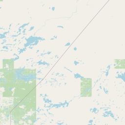
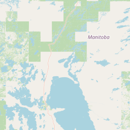
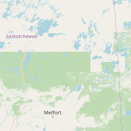
| Latitude | 51.759966666666664 |
| Longitude | -92.44092666666667 |
The vessel NONAME (mmsi 380001734) from country is currently located at 51.759967 N -92.440927 W and the last position is sent 3 months ago. At the moment the vessel is Restricted manoeuverability heading 478 degree at speed 17.2 knots, and its current draught is unknown meters. The vessel is long unknown m and large unknown m, and it's estimated to be loaded at 0%.
Timeline
The following timeline will display the list of porcalls and other events regarding the ship including tracks.
- 2024-11-21T05:56:09.012Z
First seen
This vessel has been detected for the first time by Oceanook
