H
Tug


Information related to the Tug vessel H (MMSI 241417000, IMO 9371000) from Greece with latest positions and portcalls.
| MMSI | 241417000 |
| IMO | 9371000 |
| Name | H |
| Country | Greece |
| MMSI Type | Vessel |
| Type | Tug |
| Call Sign | SVA6671 |
| Class | A |
| Id | 5c4873e164fa283195d961a7 |
| Course | 232.9 |
| Speed (kn) | 0 |
| Heading (°) | 28 |
| PAC | |
| ROT | -708.7092175811848 |
| Status | Under way using engine |


Leaflet | © OpenStreetMap contributors
| First Seen | 6 years ago |
| Last Update | 42 minutes ago |
| Positions | 543 |
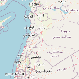
| Latitude | 37.917155 |
| Longitude | 23.086686666666665 |
| Length (m) | 29 |
| Width (m) | 9 |
| ETA | Oct 6, 2020 12:00 AM |
Distance travelled (nm)
| Since first seen | 462494.11 |
| Since last port call | 30.12 |
| Since last position | 0.09 |
Speed (kn) / Draught (m)
Draught (m)
| Current | 4 |
| Min | 4 |
| Max | 4 |
| Average | 4 |
The Tug vessel H (mmsi 241417000) from country Greece is currently located at 37.917155 N 23.086687 E and the last position is sent 42 minutes ago. At the moment the vessel is Under way using engine heading 28 degree at speed 0 knots, and its current draught is 4 meters. The vessel is long 29 m and large 9 m, and it's estimated to be loaded at 0%.
Timeline
The following timeline will display the list of porcalls and other events regarding the ship including tracks.
